Sunday, December 16, 2007

More About Roslyn, Washington (Cicely, Alaska)

A few days ago I mentioned my newly posted panos of Roslyn, Washington, also known as Cicely, Alaska, and promised to say more.

Roslyn is a picturesque small town in the eastern foothills of the Cascades (nearest sizeable town is Ellensburg). Its history centers around the coal mines and multi-ethnic populations brought in to work them. But its moment of fame came when the television series Northern Exposure was filmed there. The series is considered important enough to have its own Wikipedia entry.

The series first aired in 1990 and continued for six seasons, a total of 110 episodes. The basic premise is that a small Alaskan town pays for a medical student's education, and in return he is obligated to practice there for several years once qualified. Doctor Joel Fleischmann arrives straight from New York City, feeling as much out of place as if he had landed on Mars.

Anyone who has seen Northern Exposure will remember the vivid characters in its large cast - Doctor Joel, Maggie, Maurice, Holling, Shelly, Marilyn, Ed, Ruth-Anne and Chris. The plots are quirky and interesting, many of them revolving around the cultural friction between Jewish New Yorker Joel and his new Alaskan community and environment. But there are also some intriguing takes on Alaska itself, with its long winter nights, spring thaw, Native Americans, bears and moose, isolation, and spirit of stubborn nonconformity.

Not everyone in Alaska appreciated the characterizations. There has of course been some speculation about which town in Alaska might have been the model for Cicely, with Nenana, Talkeetna, Hope, and Homer all being suggested. And of course Washington is not a fully convincing stand-in for Alaska. For one thing the trees are wrong, also it isn't dark nearly enough in the winter episodes, nor frozen enough. But those are quibbles - the opening credits, with a young moose wandering through the town, now epitomize Alaska to many who have never been there.

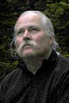
Most of the episodes begin with the "Chris in the Morning" radio show on station KBHR (kay-bear, get it?), the most local station imaginable, serving just Cicely. The DJ is Chris Stevens (played by John Corbett, also charming in My Big Fat Greek Wedding), a philosophical ex-con with a gentle voice and eclectic tastes. The KBHR set is still there in Roslyn, in the Northern Mining Company building (standard size or fullscreen). A monument to the city's coal mining heritage has now been built in front.

The "Oasis" Roslyn Cafe (standard size or fullscreen), and other series venues, including Dr Joel's office and The Brick pub, can be seen along the main street, Penn Avenue (standard size or fullscreen), but others existed only as sets. There have been a few changes in the town since 1990, but all in all it remains a gem of a northwest frontier town, with the bonus of reminding us of Northern Exposure.

Northern Exposure - The Complete Series

Northern Exposure - The Complete First and Second Seasons
Northern Exposure - The Complete Third Season
Northern Exposure - The Complete Fourth Season
Northern Exposure - The Complete Fifth Season
Northern Exposure - The Complete Sixth Season

The music in the broadcast version of Northern Exposure was exceptional, starting with the opening credits. Some DVD versions seem to have altered the sound track, but the Complete Series edition promises most of the original music. The music is also available on CD.

Northern Exposure: Music From The Television Series (1990-95 Television Series)

More Music From Northern Exposure (1990-95 Television Series)

New Panoramas of the Washington Cascades

I have been considering my new page layout and navigation experiment (see the previous blog entry and Eastern Washington) for a couple of weeks now. I have decided that I like it, and will begin gradually switching the site over to this new system.

First up - the Cascade Range of Washington. The number of panos here has gone up from 48 to 144 and features a great series along the Spirit Lake Highway leading to Mount Saint Helens.

This is one of the most dramatic parts of the Pacific Northwest, a chain of mighty volcanoes atop a rugged older range, set in a matrix of ancient forests. I first fell in love with it when my family drove from California to Seattle for the World's Fair in 1962, spending a beautiful sunny day in the meadows at Paradise on Mount Rainier. Over the years since then I have been back to Rainier several times, as well as most other major parts of the range.

New panoramas in this guidebook:

The North Cascades: Skagit River, the town of Diablo, Diablo and Ross Lakes, Washington Pass, and the Cascade River Road. These were mostly photographed in August 2006. They are all in, or on the edge of, North Cascades National Park, and along the North Cascades Highway. The scenery is stunning, and I was blessed with good weather. You can see me enjoying an evening in camp on the Cascade River (standard size or fullscreen).

Roslyn, also known as Cicely, Alaska (in the television series Northern Exposure), photographed August 16, 2006. I will write more about this interesting town later.

Sunrise, in Mount Rainier National Park, also from August 2006. I was planning a longer stay and to re-photograph the Paradise area also on this trip, but encountered some pretty severe obstacles. First, there was a huge forest fire to the northeast and visibility was poor and getting worse, plus the smoke was giving me breathing problems, especially when hiking.

But then a real disaster - the tripod mounting socket tore right out the bottom of my camera! It was really my fault, not the camera's, I was putting far too much strain on the socket with my heavy VR mount. It broke when I was hauling it carelessly out of the backpack. Live and learn. I took one final pano at Shadow Lake (standard size or fullscreen) hand-held, then called it quits. As it turned out, that was my last pano of the summer.

Mount Saint Helens was big news when it erupted explosively in May of 1980. Since then the area has been evolving steadily, the forests growing back and streams running clear. The volcano itself has had a series of smaller eruption, and is still emitting blue smoke and occasional clouds of ash. But the big change has been tourism - creation of Mount Saint Helens National Volcanic Monument and the building of a major highway approaching the mountain from Interstate 5 to the west. I revisited Mount Saint Helens in August 2007.

The Spirit Lake Memorial Highway offers a tantalizing series of views ahead to the mountain as it winds along ridges above the Toutle River. There are four major visitor centers along the route. The largest is at Coldwater Ridge, but the most popular and dramatic is right at the end of the road, the Johnson Ridge Observatory. Less traveled by far are the roads that approach Mount Saint Helens from the east side, leading to Windy Ridge.

The Cascades are densely forested from sea level to timberline, and significant areas of old growth remain among the checkerboard of clearcuts. In August 2007 I spent some time in these wonderful forests, primarily on lower Iron Creek in the Cispus River basin, and at Cedar Flats on the Muddy River. The Iron Creek campground is an experience in itself, a chance to camp among towering Douglas firs (standard size or fullscreen). Most of these panos were taken on the nature trail that circles the campground. The Cedar Flats Research Natural Area was set aside to protect the giant western red cedars growing there in swampy conditions, but also contains big trees of several other species.

A series of forest service roads give access the south side of Mount Saint Helens, including Ape Cave. At two miles this is the longest lava tube cave in North America. The Lewis River has more beautiful forests and lots of waterfalls.

The Cascade Range is cut right across by the mighty Columbia River, protected on both sides as the Columbia River Gorge National Scenic Area. The Oregon side, with hundreds of waterfalls, gets most of the attention. But the Washington side of the Columbia River Gorge is beautiful, too. Bonneville Dam blocks the river and submerges the historic Cascades for which the river was named. It is an interesting place to visit, with its powerhouse and fish ladders.

Future plans for panography in the Cascades? First of all I badly need to rephotograph the Paradise area on Mount Rainier in early summer. And I have always wanted to approach Mount Rainier from the west side, up the little-used Carbon River and Westside Roads. I tried to do this in 2007, but all the roads were washed out. I would also like to backpack into the Glacier Peak Wilderness, and take the long boat ride up Lake Chelan to Stehekin again.

New Page Layouts and Navigation

Here's the news - I have just converted one of my guidebooks, Eastern Washington, to a new format. I think it works pretty well - let me know what you think - dbain@VirtualGuidebooks.com.

When I first devised the Virtual Guidebooks site, in January 2000, there were two versions of each panorama, small and large. But technology changes fast, and the former "large" size is now my standard size. With a little coaching from Hans Nyberg (see his site Panoramas.dk) I prepared one of my panoramas to be his "fullscreen of the week". This was At the foot of Mount Whitney, to be followed by White Sands, New Mexico, and the Olympic rain forest on the Queets River. I agree with Hans that the fullscreens seem like a totally different graphic to most people, compared to small panos in context on a page.

So I began to make fullscreen versions of all my high resolution, digital camera panos. By 2004 I had fullscreens ready for a majority of my work, so I added them to almost every part of the Virtual Guidebooks site.

The problem with adding the fullscreens was that it disrupted my carefully worked out navigation. You could do a Previous-Next tour at the guidebook, locality, and standard size panorama level. But fullscreens have no place for my standard navigation bar, plus they open in a new window. It works pretty well - when you close a fullscreen window you are back where you started, the original window was just hidden underneath the fullscreen. But the asymmetry bothered me. And I never satisfactorally resolved the problem of navigation back and forth between the locality pages for standard size and fullscreen size. Also I had made larger thumbnails for the fullscreen versions, and they made the small old ones look pretty pathetic.

So I decided to have just one series of locality pages, using the large thumbnails, with links to both the standard and fullscreen panos. Both types of panos open in similar fullscreen windows. It is simpler, more consistent, and I think easier to browse than the old system. If I continue to like it I will gradually convert the entire site to this new plan.

Weekend Trip to the Mendocino Coast

Fall and winter is usually when I stay home and catch up on processing the panos taken earlier in the year and work on my site and other projects. My travel urge is satisfied by the field trip class, and the weather gets progressively less inviting. But sometimes my wife (Nora) and I just need to get away. So last weekend we cleared four days on our calendars and headed for Fort Bragg on the Mendocino Coast.

We left the Bay Area on Saturday afternoon (November 10) and had an elegant dinner in Healdsburg in the Sonoma wine country. I remember when it was just a small farm town, but now it is full of wine tasting rooms, antique shops, restaurants and art galleries. After dinner I spotted some superb wide format landscapes in the Capture Gallery and we went in. The photographer, Chistopher Foster, was there and we had a chance to chat. He is doing landscape work in large format (4x5 view camera), then scanning and stitching in PTGui. I was very impressed with the quality of his work - see christopherfoster.com. The gallery was also showing work by Joseph Holmes, who I have known since college days. Joe does natural landscapes of ultimate quality: josephholmes.com. Seeing their work inspired me to pay more attention to the possibility of printing my own panoramas.

The next day we crossed the north coast ranges through Boonville (standard size or fullscreen) in the Anderson Valley, enjoying fall colors at the Navarro Vineyards tasting room (standard size or fullscreen), then up the coast to the charming New England-style town of Mendocino. The surf was high, the sun was bright, but the wind was biting. We took a brisk walk around the headlands (standard size or fullscreen) then browsed in the Gallery Bookshop on Main Street. I bought an interesting looking book entitled Boonville: A Novel, by local author Robert Mailer Anderson, set in the town we had just passed through.

Mendocino may be familiar to many as the stand-in for fictional Crab Cove, Maine, where the Murder She Wrote television series takes place. There is a series of books that follows the series, such as: Murder, She Wrote: Coffee, Tea, or Murder? The authors are listed as Jessica Fletcher and Donald Bain. Jessica Fletcher is the fictional detective in the series, Donald Bain is a prolific "ghost writer" (no relation).

That night we had an excellent meal in the unpretentious Captain Flint seafood restaurant in the fishing boat harbor of Noyo, down under the Highway One bridge. The menu was chips with everything (fish and chips, squid and chips, clams and chips, my wife had beef and chips) and a great local beer, Scrimshaw Pilsner from North Coast Brewing Company. Recommended.

Overnight a storm blew in and by morning everything was wet and blue-gray. I went back to Noyo and shot a few atmospheric panos (standard size or fullscreen). There were lots of crab pots piled neatly on the docks, waiting for the opening of crabbing season a few days later. In the afternoon we went back to Mendocino where I shot again on the headlands, the lighting radically different than just 24 hours before (standard size or fullscreen), and a series down Main Street (standard size or fullscreen). We had a late lunch at Pattersons Pub, very cozy, then walked through wind and light rain out to the restored lighthouse at Point Cabrillo (standard size or fullscreen) as the light rapidly faded.

For dinner we returned to Noyo and tried the upscale Silvers at the Wharf, next door to Captain Flints. White tablecloths and elaborate dishes, very good but overpriced, I actually preferred Flints. Then we went back to the motel, ate angel food cake with our fingers and drank champagne from plastic cups, while watching a movie on television in bed. Monday night in Fort Bragg!

Tuesday morning was misty but at least no longer raining. I walked around the historic downtown area of Fort Bragg (standard size or fullscreen) then we started home, this time crossing the mountains on the less-traveled Comptche-Ukiah Road. Yellow leaves on the hazelnut trees livened up the dark evergreen forests, about as much fall color as we get in most parts of California (standard size or fullscreen).

We stopped at Montgomery Woods State Reserve for a short hike. This small remote grove of old growth redwoods includes some of the world's tallest trees (365 feet) and a unique swampy forest floor with head-high giant chain ferns. One of the hidden gems of Mendocino county, it is worth many miles of windy roads to see. I think the very last panorama of the trip was the best (standard size or fullscreen).

Look Up! New Cubic Versions

I am gradually adding cubic (straight up and down) versions of many of my VR panoramas to the Virtual Guidebooks site, usually replacing cylindrical versions. Since the new cubics are scattered all over the site I have made a list and will update it as the project progresses.

First, three examples of when a cubic is much better than a cylinder. In the cubic version be sure to look up!
fullscreen size:
Yosemite Falls: cylindrical or CUBIC
redwood forest: cylindrical or CUBIC
skyscrapers: cylindrical or CUBIC
standard size:
Yosemite Falls: cylindrical or CUBIC
redwood forest: cylindrical or CUBIC
skyscrapers : cylindrical or CUBIC
I have made a complete list of new cubic versions of existing panoramas (much too long to include here).

These are all replacements, and there are more to come. There will also be some big updates in the near future that will have lots of cubics - such as San Francisco. The remaining replacements (cubic for cylindrical) are mostly in Yosemite and the deserts of Southern California.

More About Cubics

In the beginning QTVR was limited to a cylindric imaging model - you could look all the way around, but only a little bit up and down. It was new and exciting and for many subjects it worked well. Eventually Apple extended the technology to support a cubic (i.e. spherical) view, so you could look straight up and straight down, as well as all the way around. It was a whole new generation of amazing, crowd pleasing computer graphics.

But there were trade-offs. The VR file either had to be bigger to show a larger view, or if bandwidth was an issue, you had to reduce resolution. If there was really nothing up there but more blue sky, or down below but dirt or grass, why reduce resolution? So for most landscape subjects I stuck with the cylindrical view.

Another issue was the software. The first really good VR panorama production environment was Apple's QuickTime VR Authoring Studio, which only did cylinders. The two main programs that did cubic stitching had severe problems: PanoTools was ridiculously cumbersome to use; RealViz Stitcher was expensive and quirky and it was hard to get good results. I wasted a lot of time with those two programs, and only ever produced a few good cubics.

But some subjects just had to have more vertical field of view - cliffs, forests, tall buildings, deep canyons. Beginning in 2001 I was shooting multi-row cubics even though I wasn't finishing and posting any on the site.

I finally got started with cubic stitching a year ago, using PTMac. But there were still quality and efficiency issues, a lot of time spent manually assigning control points and retouching stitching problems in Photoshop. The breakthrough came when the program PTGui was ported to the Mac, with automatic control point generation that actually worked. Paired with CubicConverter it makes an excellent cubic panorama production system. Receomended.

I already had hundreds of cubics lined up ready to go. It took several months to work my way through, setting up the files then running the batch stitcher overnight. Then I had to examine each one, and sometimes make adjustments and stitch again. When I had a good stitch there still was some obligatory Photoshop work. So it has been about a year in progress, but now I am finally able to put these cubics on the site.

Some of these have never been posted before, but most are replacing a cylindrical version. In some cases I probably shouldn't have put up the cylinder in the first place, like my Yosemite waterfalls with the top cut off. But usually I offered a cylinder as a placeholder until I could produce a cubic.

Now I shoot cubics routinely and process the cylinders and cubics all together in the same workflow. For maximum quality I sometimes use a multi-tier approach (shooting a level tier, a tier up and another down), but usually I shoot cubics with a fisheye lens, a fast and efficient procedure.

Some VR photographers sneer at cylinders as being old-fashioned and inadequate. I disagree, and still shoot about 80% cylinders . They have a few inherent advantages - higher resolution from the same camera, easier to deal with certain types of moving objects, and more appropriate for printing "unwrapped". If there is important scene detail up above or down below, I put on the fisheye and shoot a cubic. But if there is just more sky and dirt, or if I see potential for a print, I still use a normal wide angle lens to make a cylinder. My cubics tend to be concentrated in certain landscape types - forests, canyons, and cities. Sometimes I shoot a cubic to capture a great cloud-scape.

As of today 164 cubics have been placed on the site to replace cylinders, with another 100 coming to finish the job (mostly Yosemite and the deserts of Southern California). Panoramas taken over the last year, and from now on, will be a mix of cubics and cylinders.

Panoramas and the Geography Field Class

It is hard to imagine that I could travel thousands of miles through spectacularly beautiful and interesting country and not take any panoramas. How could that be?

Every fall semester for the last eight years I have taught a field class in the Geography Department at the University of California Berkeley (as part of my real job - Virtual Guidebooks is a sideline). It is a great experience, both for the students and for me, but it leaves me little time for photography. As the instructor I have a lot on my mind, and just cannot muster the unique combination of creative thought and technical concentration necessary for shooting panoramas. Also we move very fast on these trips, driving as much as a thousand miles in a long weekend, plus hikes, talks, making and breaking camp, meals and campfires (sleep is optional).

Last fall semester (September 2006) I just had to take a pano on a field trip, because it was the window for the World Wide Panorama and my last chance. So for the theme "Transportation" I shot a quickie of the group setting up camp in the deep woods of northeastern California. It is entitled simply Field Trip! At Mossbrae Falls, the last stop of that same trip, I shot another with a very different mood (standard size or fullscreen).

On the second trip in 2006 I shot a partial panorama of our empty camp at the base of the dunes in Eureka Valley (standard size or fullscreen). Camp is empty because all the students were off trudging up the 700-foot high "sand mountain" at the time. On the third trip I shot a series of panos on the hike to the summit of Cone Peak in the Santa Lucia Mountains above Big Sur.

This year I missed lots of great panorama subjects on the first trip to Mount Lassen and Mount Shasta, and also on the second trip up the Redwood Highway. Not a single panorama! But I was determined to get something on the third and final trip, east of the Sierra.

The very first morning I shot next to a Joshua tree at sunrise in Red Rock Canyon (standard size or fullscreen). You can see the field class moving around our vehicles, drinking coffee and packing up to hit the road.
The next day in the Alabama Hills I arranged the students around me in a big circle and shot another pano. The opening view (standard size or fullscreen) shows Genki and our big truck (the Beast), pan it around right to Devin, then to Ryan being leaned on by big Dan (my co-leader), Heather is off in the distance, twice, then Katie K, myself, followed by Katie R. One of my favorite field trip groups. Several other students were elsewhere with Prof Cuffey at the time.

Only two panos for all that traveling, next year I shall have to do better!

New Panoramas of British Columbia

It has been a long time since I posted new panoramas on the site. Mostly I have been catching up on other VR projects, such as art quality prints, and cubic versions. There have only been two big updates in the last year.

In the guidebook to the Coast and Islands of British Columbia I have added a comprehensive section on the Sunshine Coast. These photos were taken when I was up there visiting my cousins Anne and Clive at their vacation house in Powell River in August 2006. The weather was beautiful, except for the day my cousin Heather (visiting from England) and I took the all-day boat tour to Princess Louisa Inlet. That day it just poured rain, all day without letup.

The Sunshine Coast is divided into eight localities, from Lund in the north to the Langdale-Horseshoe Bay Ferries in the south. My favorites are of kayakers at Smugglers Cove (standard size or fullscreen) and Bella Beach in Sechelt (standard size or fullscreen).

The other big update is actually a complete makeover. I originally covered the city of Vancouver, British Columbia very early on, when I was still using film. I can do much better now, with a digital SLR, plus I can do cubics easily, important for a city with so many tall buildings. So I spent three days there in August 2006 and walked all over the city.

I stayed at the Lonsdale Quay Hotel in North Vancouver and took the Seabus ferry over to Vancouver proper each day - much more efficient than dealing with my car in the city. The hotel was a lively, interesting place, with a mall and food hall underneath (standard size or fullscreen), several restaurants, and great views across the water (standard size or fullscreen). Recommended.

The new VR panoramas of Vancouver are in the guidebook to Vancouver and the Lower Mainland. It is divided into nine localities, starting with the Western shoreline of Stanley Park and progressing south and east to Gastown. There are also two new localities north of the city: Horseshoe Bay and North Vancouver.

My favorites are of the bagpiper at Brockton Point (standard size or fullscreen) (which I used as my Best of 2006 on the World Wide Panorama site) and inside the amazing new Vancouver Public Library (standard size or fullscreen).

I was back in Vancouver in August 2007 for my niece Sarah's wedding, but was too busy to do much photography. All I managed was an hour or so at Queen Elizabeth Park.

I am not done with Vancouver yet. There are still some important neighborhoods to cover (Chinatown, False Bay, Granville Island, UBC), and things are changing fast, as they prepare to host the Winter Olympics in 2008.

Welcome to the Virtual Guidebooks Blog

People keep asking me to start a blog (web log, a periodic posting of news and views) about my website: Don Bain's Virtual Guidebooks. So here it is!

The blog posts will appear here, on Blogger (VirtualGuidebooks.BlogSpot.com) and also on the home page of the Virtual Guidebooks site.

My plan is to use the blog for several things.

• To alert my regular visitors when new panoramas have been added to the site. The new ones tend to get lost amongst the huge number already on the site.

• To tell you about my travels, which will usually include a few preview images. It often takes me as much as a year to finish the panos from a major trip and get them all on the site.

• To present more information about places that I feature on the site. This will include history, geography, and links to books, movies, and websites.

• To announce new projects, such as my plan to sell fine art prints of my panoramas.

I welcome feedback - email me: dbain@virtualguidebooks.com
Don Bain